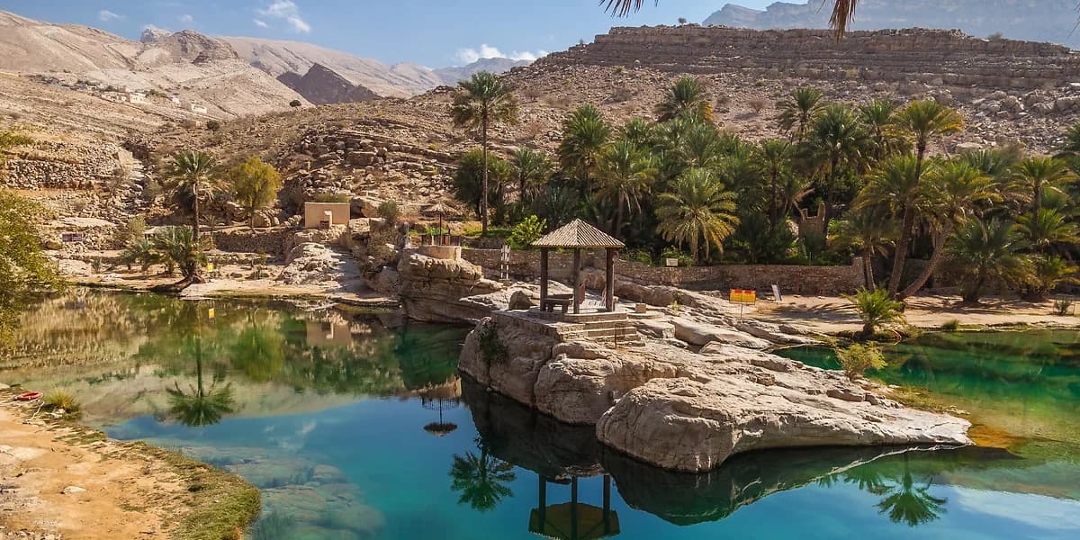
Oman Destinations
TRAVEL GUIDE

Destinations

65 destinations across 8 regions — from the fjords of Musandam to the monsoon valleys of Dhofar.

65
Destinations
8
Regions
11
Governorates
Oct–Mar
Peak Season
Type:
EDITOR'S PICKS

Must-See Destinations

EXPLORE BY REGION

All Regions of Oman

ALL DESTINATIONS

79 Destinations Found

Muscat — Capital City
🏙️ City
🚗 2WD
Muscat

Muscat

Oman's coastal capital blends ancient heritage with modern elegance. A clean, safe, welcoming city with world-class architecture, pristine beaches, a historic old town, and easy access to day trips across the country.

CultureHeritageBeaches
🕐 Oct – Mar
📍 0 kmExplore →
Daymaniyat Islands
🐠 Marine Reserve
Boat
Muscat

Daymaniyat Islands

Drop beneath the surface and the reef appears immediately — brain coral the size of cars, reef sharks in slow arcs, hawksbill turtles gliding through blue water so clear the bottom is visible at 20 metres. These nine uninhabited islands hold the cleanest, most biodiverse reefs within reach of Muscat, protected since 1996 and never touched by shore development.

DivingSnorkelingWildlife
🕐 Oct – Apr
📍 18 km offshoreExplore →
Bandar Al Khayran
Coastal Reserve
🚙 4WD
Muscat

Bandar Al Khayran

Paddle a kayak around a limestone headland and the world goes completely quiet — no roads, no buildings, just the drip of water off your blade and the hollow resonance of the sea cave opening ahead. This sheltered coastal reserve 40 km south of Muscat hides a network of coves, lagoons, and caves that can only be reached by water.

KayakingDivingSnorkeling
🕐 Oct – Apr
📍 40 kmExplore →
Majlis Al Jinn Cave
🕳️ Cave
🚙 4WD
Muscat

Majlis Al Jinn

Stand at the edge of a 160-metre vertical shaft cut through solid limestone and listen: nothing, then a whisper of cool air rising from a chamber so vast it has its own weather system. Majlis Al Jinn is the second-largest cave chamber on earth by surface area — large enough to fit the Great Pyramid of Giza inside — accessible only by expert rappelling down one of three freefall entrance shafts.

AdventureRappellingCaving
🕐 Oct – Mar
📍 150 kmExplore →
Salmah Plateau
📍 Plateau
🚙 4WD
Muscat

Salmah Plateau

Salmah Plateau is the kind of place that changes your sense of scale as soon as you climb onto it. The coast drops away behind you, the surface opens into a pale undulating highland, and the usual landmarks of travel disappear into track, rock, wind, and distance. What makes it memorable is not one single viewpoint but the feeling of being on a broad karst world with almost no visual clutter between you and the landscape.

Plateau4WDKarst
🕐 Oct - Apr
📍 150-165 kmExplore →
The Rustaq Loop
🚗 Heritage Drive
🚗 2WD
Al Batinah

Rustaq Loop

Three forts, a sulphurous hot spring, and mountain passes through date palms into bare limestone — all connected by a single circular road that most tourists miss while driving straight to Nizwa. The Rustaq Loop traces a semicircle through the oldest inhabited valley in Al Batinah, where water, trade, and military power have intersected for over a thousand years.

HeritageFortsHot Springs
🕐 Oct – Apr
📍 80 km to BarkaExplore →
Wadi Mistal
💧 Wadi
🚗 2WD
Al Batinah

Wadi Mistal

The road narrows through a cliff gap, then the valley opens without warning into the Ghubrah Bowl — a basin ringed by naked limestone that makes you feel the full scale of the Western Hajar in a single glance. Wadi Mistal is not a wading destination but a landscape destination, where acacia-dotted flatland leads upward into the high mountain villages of Wakan, Hadash, and Al Hijir.

WadiMountain DriveHiking
🕐 Oct - Apr; blossoms Feb - Mar
📍 135-150 kmExplore →
Wakan Village
🏡 Mountain Village
🚙 4WD
Al Batinah

Wakan Village

At 2,000 metres in the Western Hajar, Wakan smells different from every other village in Oman — in February and March the apricot orchards that ring the stone houses release a scent that carries across the entire valley. The village perches above the Ghubrah Bowl, its terraced gardens stepped down the slope below traditional stone architecture unchanged in generations.

MountainHikingViews
🕐 Feb – Apr
📍 150 kmExplore →
Wadi Bani Awf & Snake Canyon
💧 Wadi
🚙 4WD
Al Batinah

Wadi Bani Awf

The descent from 2,000 metres of bare plateau through Snake Canyon to the Batinah Plain is the most dramatic off-road passage in northern Oman — narrow enough in places to feel the cliff walls through the window, steep enough to require total concentration, and long enough to understand what the Hajar Mountains actually are from the inside.

Off-RoadCanyonCanyoning
🕐 Oct – Apr
📍 120 kmExplore →
Little Snake Canyon
📍 Canyon
🚙 4WD
Al Batinah

Little Snake Canyon

Between two canyon walls close enough to touch on both sides, the water is knee-deep, cold, and coloured a jade green that deepens with every step into the shade. Little Snake Canyon is the beginner entry point to the Wadi Bani Awf canyon system — shorter and less technical than Snake Canyon proper, but with the same limestone corridors and zigzag pools that define this mountain landscape.

CanyonWadiHiking
🕐 Oct - Apr
📍 125 kmExplore →
Wadi Sahtan
💧 Wadi
🚙 4WD
Al Batinah

Wadi Sahtan

Wadi Sahtan opens into a wide mountain basin that feels more like a highland valley than a canyon — date palms, falaj channels, traditional villages, and the smell of woodsmoke from houses still inhabited the same way they have been for centuries. The wadi begins near Rustaq and extends into the Western Hajar through increasingly remote terrain that most visitors to the Rustaq Loop never reach.

WadiMountain DriveVillages
🕐 Oct - Apr
📍 160 kmExplore →
Wadi Hoqain
💧 Wadi
🚗 2WD
Al Batinah

Wadi Hoqain

The pools at Hoqain are a specific shade of mineral blue — not turquoise, not green, but a milky blue-green that signals dissolved limestone and cool mountain water filtering through the Western Hajar. A small waterfall drops into a picnic-friendly basin within walking distance of the village, making this one of the few places near Rustaq where families can swim without a strenuous approach.

WadiWaterfallBlue Pools
🕐 Oct - Apr
📍 150 kmExplore →
Wadi Bani Hany
💧 Wadi
🚙 4WD
Al Batinah

Wadi Bani Hany

South of Hoqain and below the sight line of most Rustaq day-trippers, Wadi Bani Hany carries on as it always has — palm groves running along dry streambeds, stone buildings half-swallowed by vegetation, and the sound of water in channels that feed fields nobody outside the village will see today.

WadiVillageMountain Drive
🕐 Oct - Apr
📍 155 kmExplore →
Barka
Coastal Town
🚗 2WD
Al Batinah

Barka

On Friday mornings between October and April, the sandy arena behind Barka fills with the sound of shoulder meeting shoulder and hooves striking earth — the bull-wrestling event that has taken place here for centuries, a test of strength between bulls with no blood and no harm, where the loser simply retreats.

HeritageBeachesCulture
🕐 Oct – Apr
📍 80 kmExplore →
Sohar
🕌 Historic City
🚗 2WD
Al Batinah

Sohar

One of Oman's oldest cities and the legendary birthplace of Sinbad the Sailor. Once the wealthiest port city in the Arab world, Sohar combines history and contemporary amenities between the Hajar Mountains and the Arabian Sea.

HeritageMaritimeCulture
🕐 Oct – Mar
📍 225 kmExplore →
Nizwa — Pearl of Islam
🕌 Historic City
🚗 2WD
Ad Dakhiliyah

Nizwa

Oman's most important historical city, former capital in the 6th–7th centuries, and the country's cultural heartland. A UNESCO-recognized falaj system, one of the Arabian Peninsula's largest forts, and a famous traditional souq.

HeritageSouqCulture
🕐 Oct – Mar
📍 160 kmExplore →
Salut Archaeological Site
🗿 Archaeological Site
🚗 2WD
Ad Dakhiliyah

Salut

Salut does not overwhelm you through size alone. Its power comes from placement: a fortified hill rising above an oasis plain, with the sense that every wall, terrace, and passage was built because water, defence, and survival once had to work together with absolute precision. Walk it slowly and the site begins to feel less like a ruin and more like a high vantage point into how inland Oman first learned to organise settlement at scale.

ArchaeologySalutBisya
🕐 Oct - Apr
📍 190-210 kmExplore →
Jebel Akhdar — Green Mountain
⛰️ Mountain
🚙 4WD
Ad Dakhiliyah

Jebel Akhdar

In late March, the terraces of Jebel Akhdar smell of roses — not the faint garden variety, but the concentrated attar of Damask roses being harvested and distilled in small copper stills that have worked this same mountain for three hundred years. At over 2,000 metres, the Green Mountain holds a microclimate that allows the only commercial rose cultivation in the entire Arabian Peninsula.

MountainHikingViews
🕐 Oct – May
📍 200 kmExplore →
Wadi Bani Habib
📍 Historical Landmark
🚙 4WD
Ad Dakhiliyah

Wadi Bani Habib

A stone path with 200 steps descends from the viewpoint into a canyon where abandoned houses stand intact above apricot orchards that still bloom every spring despite no one tending them. Wadi Bani Habib is Jebel Akhdar's most evocative site — an entire village left in such precise condition that you can stand in a doorway and understand exactly how the rooms were arranged.

Historical LandmarkHeritageAbandoned Village
🕐 Oct - Apr; rose season Mar - Apr
📍 205 kmExplore →
Jebel Shams & Wadi Ghul
⛰️ Mountain
🚙 4WD
Ad Dakhiliyah

Jebel Shams

The wind at the canyon rim of Wadi Ghul comes from below — rising from a kilometre of vertical limestone you cannot fully comprehend until you stop walking and stand at the edge. Jebel Shams reaches 3,009 metres, but what makes it the finest high point in Oman is what it stands above: the deepest canyon in the Arabian Peninsula, dropping 1,000 metres to a wadi floor you can barely distinguish.

MountainHikingCanyon
🕐 Oct – Mar
📍 240 kmExplore →
Wadi Nakhr - Grand Canyon of Oman
📍 Canyon
🚙 4WD
Ad Dakhiliyah

Wadi Nakhr

From the village of Ghul on the canyon rim, Wadi Nakhr stretches below in a series of layered limestone terraces and narrow wadi floors so far down that the vegetation looks like moss — this is the grand view of Oman's most dramatic canyon system, accessible to anyone willing to drive to the edge.

CanyonWadiGrand Canyon
🕐 Oct - Apr
📍 240 kmExplore →
Al Hoota Cave
🕳️ Cave
🚗 2WD
Ad Dakhiliyah

Al Hoota Cave

In the underground lake at Al Hoota Cave, small pale fish move through the water with precise navigation despite having never evolved eyes — the Garra barreimiae has lived in permanent darkness long enough that sight became irrelevant. The cave extends 4.5 kilometres beneath the Hajar Mountains, formed over two million years, and the illuminated section contains enough stalactites and underground lakes to make the 45-minute guided walk one of the strangest landscapes in Oman.

CaveNatureFamily
🕐 Year-round
📍 167 kmExplore →
Al Hamra & Misfat Al Abryeen
🏘️ Heritage Village
🚗 2WD
Ad Dakhiliyah

Al Hamra & Misfat

Water runs through Misfat Al Abryeen in channels carved from rock centuries ago, feeding terraced gardens of date palms and orchards that hang off a stone outcrop like a village impossibly balanced on the Hajar foothills. The sound of running falaj water is constant here — it defines the texture of the place in a way that makes Misfat immediately distinct from every other heritage village in Oman.

HeritageVillageArchitecture
🕐 Oct – Apr
📍 200 kmExplore →
Al Hamra Old Town
📍 Heritage Town
🚗 2WD
Ad Dakhiliyah

Al Hamra Old Town

Al Hamra Old Town is the kind of place that rewards a slower pace almost immediately. The lanes are narrow, the walls are textured by age rather than polish, and the whole settlement seems to sit somewhere between endurance and elegance. Walk through it in soft light and what stands out is not only the architecture itself, but the feeling that the town still carries its own memory in doorways, stairways, and shadowed passages.

HeritageOld TownMudbrick
🕐 Oct - Apr
📍 200 kmExplore →
Hat Village
🏡 Mountain Village
🚙 4WD
Ad Dakhiliyah

Hat Village

Hat is not the kind of place that arrives with ticket booths, signs, or a performance of authenticity. You reach it on one of Oman's great mountain crossings, after the drama of Wadi Bani Awf and before the high saddle of Sharaf Al Alamayn, when the road becomes quieter and every bend feels like it belongs more to the mountains than to you. The village itself is modest, but that is part of the appeal: stone homes, terraces, and a setting that makes the whole stop feel like a pause inside the landscape rather than beside it.

VillageMountainsWadi Bani Awf
🕐 Oct - Apr
📍 175 kmExplore →
Birkat Al Mouz & Bait Al Radidah
🏘️ Heritage Village
🚗 2WD
Ad Dakhiliyah

Birkat Al Mouz & Bait Al Radidah

Birkat Al Mouz has the rare kind of beauty that unfolds in layers. First come the date palms and the long line of ruined mudbrick houses, then the sound of running water, then Bait Al Radidah rising at the edge of the village with Jebel Akhdar behind it. Nothing here feels isolated from anything else. The fort, the falaj, the orchards, and the old village all belong to one continuous landscape, which is exactly why the place feels more alive than most heritage sites ever do.

HeritageOasisFalaj
🕐 Oct - Apr
📍 165 kmExplore →
Manah Old Town (Harat Al Bilad)
📍 Heritage Town
🚗 2WD
Ad Dakhiliyah

Harat Al Bilad

Harat Al Bilad is one of those places that does not need drama added to it. You arrive in Manah, step toward the old quarter, and suddenly the scale of traditional settlement planning becomes visible all at once: walls, gateways, towers, lanes, and the dense geometry of homes once built for heat, defence, and community rather than spectacle. What stays with you is not only the age of the place but how complete the atmosphere still feels.

HeritageOld TownMudbrick
🕐 Oct - Apr
📍 160 kmExplore →
Wadi Tanuf & Tanuf Ruins
💧 Wadi
🚗 2WD
Ad Dakhiliyah

Wadi Tanuf & Tanuf Ruins

Tanuf is the kind of place that slows you down before you realise it has. A turn off the main road between Nizwa and Bahla leads into a broad canyon mouth where mudbrick walls stand half-dissolved into the earth, the cliffs of the Hajar rising behind them like a stage set too large for the village below. Walk a little farther and the mood changes again: the wadi opens, palms and water soften the scene, and the whole place becomes less about ruins than about how beautifully life once fit into this landscape.

WadiRuinsHeritage
🕐 Oct - Apr; after rainfall for the wadi
📍 165 kmExplore →
Bahla Fort & Town
🏅 UNESCO Heritage
🚗 2WD
Ad Dakhiliyah

Bahla Fort

The mud-brick walls of Bahla stretch for 12 kilometres around the oasis town — a fortification so vast that its full scale only becomes clear from the road, where the ramparts appear and disappear behind date palms for minutes at a time. Oman's first UNESCO World Heritage Site is not a single building but an entire ancient urban system: fort, town walls, oasis, and traditional market still functioning together.

UNESCOHeritageForts
🕐 Oct – Apr
📍 200 kmExplore →
Jabrin Castle
🏰 Castle
🚗 2WD
Ad Dakhiliyah

Jabrin Castle

Look up at the ceiling of Jabrin Castle's main hall and the painted panels tell a story in colours — botanical, geometric, celestial — that have survived without restoration since 1670. The Imam who commissioned this castle created something Oman did not repeat: a royal residence that was simultaneously a centre of Quranic learning, with study rooms built into military architecture in a way that makes the building feel genuinely inhabited by ideas.

HeritageArchitectureCastle
🕐 Oct – Apr
📍 210 kmExplore →
Wadi Hawir
💧 Wadi
🚗 2WD
Ash Sharqiyah

Wadi Hawir

Somewhere inside Wadi Hawir, after 20 minutes of scrambling through wet rock and swimming across a pool you cannot touch the bottom of, a 40-foot waterfall drops into a chamber that no road reaches. The wadi runs parallel to the famous Wadi Bani Khalid but shares none of its infrastructure — no café, no paved path, no restrooms, and rarely anyone else.

AdventureSwimmingWaterfall
🕐 Oct – Mar
📍 200 kmExplore →
Wadi Bani Khalid
💧 Wadi
🚗 2WD
Ash Sharqiyah

Wadi Bani Khalid

The turquoise of Wadi Bani Khalid's pools is the specific colour of limestone-filtered water at its most concentrated — a shade that exists in photographs but still surprises in person, set against white canyon walls and date palms watered by this same source for centuries. Of the hundreds of wadis in Oman, Bani Khalid is the only one with flowing water every single day of the year.

SwimmingFamilyNature
🕐 Oct – Mar
📍 200 kmExplore →
Wahiba Sands
🏜️ Desert
🚙 4WD
Ash Sharqiyah

Wahiba Sands

The first dune crest above camp at dawn — when orange sand meets blue-black sky and the silence is absolute except for wind movement — is the moment that makes everything about the Wahiba Sands worth it. These dunes reach 100 metres, formed over millions of years along a geological corridor that funnels sand from the Arabian interior toward the sea.

DesertCampingAdventure
🕐 Oct – Mar
📍 200–250 kmExplore →
Bidiyah Dunes
🏜️ Desert
🚙 4WD
Ash Sharqiyah

Bidiyah Dunes

The golden wall of the Sharqiya Sands rises directly behind Bidiyah town without transition — no gradual slope, no warning landscape, just tarmac ending and dune beginning. This northern access point to the Wahiba Sands is the easiest place in Oman to be standing in a real desert within three hours of Muscat.

DesertDunesBidiyah
🕐 Oct - Mar
📍 200-230 kmExplore →
Al Mudhairib Heritage Town
📍 Heritage Town
🚗 2WD
Ash Sharqiyah

Al Mudhairib

Al Mudhairib is the kind of place that rewards a deliberate stop. From the main route it looks modest, but once you step into the old quarter the mood changes quickly: narrow lanes, restored and ruined structures side by side, and watchtowers positioned as if the village still expects to keep an eye on the horizon. It feels less curated than many better-known heritage sites, which is exactly why it leaves a stronger impression.

HeritageVillageWatchtowers
🕐 Oct - Apr
📍 190 kmExplore →
Ibra
📍 Historic Town
🚗 2WD
Ash Sharqiyah

Ibra

On Wednesday mornings, Al Minzafah market fills with Omani women selling spices, silver jewellery, embroidered cloth, and medicinal herbs to other Omani women — one of the only women-dominated market spaces remaining in the country, where men may enter the periphery but the dynamic and the commerce are entirely controlled by the sellers.

HeritageCultureSouq
🕐 Oct – Apr
📍 180 kmExplore →
Wadi Dima Wa'ttayeen
💧 Wadi
🚗 2WD
Ash Sharqiyah

Wadi Dima

The rock in Wadi Dima is not the beige limestone of the coastal wadis but polished ophiolite — dark green and brown oceanic crust pushed to the surface millions of years ago, creating pools with a different quality of light and depth than anywhere on the Sur highway. The wadi extends from the Al Sharqiyah Expressway into the Eastern Hajar through palm groves, white calcite deposits, and water running blue-green from the mineral content of the springs.

WadiPalm GrovesSprings
🕐 Oct - Mar
📍 170 kmExplore →
Wadi Al Arbeieen
💧 Wadi
🚙 4WD
Muscat

Wadi Al Arbeieen

The approach to Wadi Al Arbeieen follows a rough track past villages where residents have watched the same wadi fill and recede with every rain for generations — before you reach the water, you have already understood that this is not a managed tourist site but an actual Omani landscape. The pools are deep and turquoise, set below canyon walls that rise sharply enough to cast long morning shadows across the water well into the afternoon.

WadiSwimmingWaterfall
🕐 Oct - Apr
📍 90 kmExplore →
Wadi Dayqah Dam
📍 Dam
🚗 2WD
Muscat

Wadi Dayqah Dam

The turquoise of the Dayqah reservoir sits between ridgelines of jagged Eastern Hajar limestone in a colour combination that looks engineered but is entirely geological — dark rock, pale water, and a haze above the dam wall that carries sound differently than open land. Oman's largest dam opened in 2012, and the reservoir it created is now large enough to kayak for hours without doubling back.

DamWadiReservoir
🕐 Oct - Apr
📍 75-85 kmExplore →
Wadi Shab
💧 Wadi
🚗 2WD
Ash Sharqiyah

Wadi Shab

You swim through three pools before the canyon walls close completely and the light from the entrance disappears — then the gap in the rock reveals a cave, and inside the cave a waterfall drops from darkness into a lit pool where sound is entirely enclosed and everything reverberates. This is the moment that Wadi Shab exists for: a hidden cave with a waterfall inside a mountain, accessible only by swimming through the final passage.

SwimmingWaterfallHiking
🕐 Oct – Mar
📍 140 kmExplore →
Wadi Tiwi
💧 Wadi
🚙 4WD
Ash Sharqiyah

Wadi Tiwi

The tarmac road into Wadi Tiwi is narrow enough that two passing cars require one to fold the mirror — but the drive through the gorge past inhabited villages, orange rock walls, and terraced date palm gardens is the most scenic wadi drive on the coastal highway, and almost nobody takes it because Wadi Shab is 500 metres away.

SwimmingScenic DriveVillage
🕐 Oct – Mar
📍 140 kmExplore →
Wadi Mibam
💧 Wadi
🚙 4WD
Ash Sharqiyah

Wadi Mibam

Above Mibam village, where the road becomes a path and the path becomes a rope-assisted scramble, a waterfall drops into a pool that sees fewer than a hundred visitors a year. The descent is steep enough to require care on wet rock, dramatic enough to make the effort feel earned, and positioned deep enough inside Wadi Tiwi that the silence at the bottom is complete.

WaterfallSwimmingHiking
🕐 Oct - Mar
📍 165 kmExplore →
Bimmah Sinkhole
📍 Natural Wonder
🚗 2WD
Ash Sharqiyah

Bimmah Sinkhole

The sinkhole appears at the edge of Hawiyat Najm Park as a perfect circle of turquoise water cut into the limestone plateau — it looks designed, but the formation is entirely natural, caused by bedrock dissolution and the subsequent collapse of what had been cave ceiling.

SwimmingFamilyNature
🕐 Year-round
📍 130 kmExplore →
Fins Beach
🏖️ Beach
🚙 4WD
Ash Sharqiyah

Fins Beach

The rocky headlands at Fins close around the bay like a natural wall, and the water inside the enclosure goes through three distinct shades of blue from shore to deep — pale turquoise over sand, aquamarine over rock, and a deep indigo beyond the reef edge where the snorkeling begins to get serious.

BeachSwimmingSnorkeling
🕐 Oct – Mar
📍 150 kmExplore →
Sur
🚢 Coastal City
🚗 2WD
Ash Sharqiyah

Sur

In the dhow yard south of Sur, men work wood with adzes and planes shaped from memory rather than instruction manuals — the same tools, the same joints, the same proportions that carried Omani merchants to Zanzibar and the Malabar Coast for a thousand years. The sound of the yard in the morning, hammers and the smell of teak and sealant, is a working environment that happens to be one of Oman's most remarkable living heritage sites.

HeritageMaritimeDhow Building
🕐 Oct – Mar
📍 330 kmExplore →
Ras Al Jinz Turtle Reserve
📍 Wildlife Reserve
🚗 2WD
Ash Sharqiyah

Ras Al Jinz

At 2am on the beach at Ras Al Jinz, a female green turtle that has navigated the Indian Ocean using the earth's magnetic field surfaces through the waves and begins the slow crawl up the sand to the precise spot where she was born — a 200-kilogram animal acting on a biological instruction so old it predates the Arabian Peninsula in its current form.

WildlifeTurtlesNature
🕐 Jul – Nov (nesting peak)
📍 400 kmExplore →
Pink Lake Oman - Al Suwaih
📍 Salt Lagoon
🚗 2WD
Ash Sharqiyah

Pink Lake Oman

The pink is not guaranteed and not permanent — it appears when the salinity, the Dunaliella algae bloom, and the angle of midday light align, which can happen on any bright day between autumn and spring and disappear entirely after tidal mixing. When the conditions are right, the lagoon near Al Suwaih turns a colour that exists nowhere else in Oman and almost nowhere on the Arabian Peninsula.

Pink LakeLagoonCoast
🕐 Oct - Apr; colour varies by season
📍 300 kmExplore →
Wadi & Sadd Al Aqeeda
💧 Wadi
🚗 2WD
Ash Sharqiyah

Wadi & Sadd Al Aqeeda

This is the kind of place you go when you want the day to feel wider, quieter, and less scheduled. Around Wadi Naam and Sadd Al Aqeeda, the landscape opens into low desert hills, village edges, and rain-fed channels that only show their best character when the season has been kind. When water gathers behind the dam or moves through the wadi after good weather, the whole area shifts from ordinary to deeply calming in the span of a single turn off the road.

WadiDamRecharge Dam
🕐 Oct - Apr; best after rainfall
📍 190 kmExplore →
Masirah Island
🏝️ Island
🚢 Ferry
Ash Sharqiyah

Masirah Island

From June through September, the wind at Masirah comes from the south at 25 to 35 knots with a consistency that professional kitesurfers call the most reliable wind corridor in the Middle East — long flat-water runs, thermal lift from the heated land, and conditions that coaches pay for their athletes to train in.

KitesurfingTurtlesBeaches
🕐 Oct – Apr (nature); May–Sep (kitesurfing)
📍 600 kmExplore →
Ibri & Bat Tombs
🗿 Archaeological Site
🚗 2WD
Ad Dhahirah

Ibri & Bat Tombs

The beehive tombs at Bat rise from the hillside in their original positions — not reconstructed, not fenced into an interpretive trail, but sitting where they were placed five thousand years ago by people whose civilisation left almost nothing else this well-preserved anywhere on earth. The UNESCO designation acknowledges what the landscape makes obvious: these tombs are the primary evidence that an organised Bronze Age society managed the copper and frankincense trade here at the same time Egypt was building pyramids.

UNESCOArchaeologyHeritage
🕐 Oct – Apr
📍 240 kmExplore →
Al Ayn Beehive Tombs
🏅 UNESCO Heritage
🚗 2WD
Ad Dhahirah

Al Ayn Beehive Tombs

Al Ayn is the kind of place that feels cinematic before it feels historical. The tombs stand one after another along a rocky ridge above Wadi Al Ayn, each one small enough to approach on foot but together powerful enough to hold the whole landscape still. With Jebel Misht rising behind them and the wadi opening below, the site offers something rare: ancient architecture that still feels completely at home in its original setting.

UNESCOArchaeologyBeehive Tombs
🕐 Oct - Apr
📍 255 kmExplore →
Wadi Damm
💧 Wadi
🚙 4WD
Ad Dhahirah

Wadi Damm

The polished ophiolite rock at Wadi Damm is so smooth and coloured so specifically — dark green-brown with veins of lighter stone — that the canyon floor looks surfaced rather than natural. Seasonal pools collect in bowls worn into the rock by centuries of water movement, and petroglyphs pecked into the cliff face near the canyon mouth document a human presence here from approximately 600 BC.

WadiPoolsWaterfall
🕐 Oct - Apr; after rainfall for pools
📍 285 kmExplore →
Al Kittan Cave
🕳️ Cave
🚙 4WD
Ad Dhahirah

Al Kittan Cave

Al Kittan Cave lies near Al Iraqi, about 8 kilometres from Ibri, in the limestone country of Ad Dhahirah. Official Omani tourism material consistently describes it as the 'marble cave' because of the pale, highly reflective cave walls, but it is better understood as a protected wild karst cave rather than a developed show cave. Inside are stalactites, stalagmites, and older rock markings that give the site both geological and human depth.

CaveKarstLimestone
🕐 Oct - Apr
📍 287 kmExplore →
Al Buraimi
🌴 Oasis Town
🚗 2WD
Al Buraimi

Al Buraimi

Al Buraimi shares a continuous streetscape with Al Ain across a border that has been meaningful for only 50 years — before that, this was a single Buraimi Oasis where trade routes from the Persian Gulf, Arabia, and the Indian Ocean interior converged, watered by 49 separate falaj irrigation systems still carrying water through the same channels they were designed for.

HeritageFortsCulture
🕐 Oct – Mar
📍 325 kmExplore →
Musandam Peninsula & Khasab
🛥️ Fjords
✈️ Flight
Musandam

Musandam

Standing at the bow of a dhow moving through the Musandam khors, the fjord walls rise on both sides to 1,500 metres of bare limestone — the exact view that produced the name 'Norway of Arabia,' except the water is warmer, the dolphins are more numerous, and the scale is somehow more complete.

FjordsDhow CruiseDiving
🕐 Oct – Apr
📍 Flight: 1 hr | Road: 5–6 hrsExplore →
Barr Al Hikman Peninsula
🌿 Nature Reserve
🚙 4WD
Al Wusta

Barr Al Hikman

At low tide on Barr Al Hikman, the tidal flat extends so far in every direction that the horizon becomes ambiguous — land and sky the same pale colour, water only visible at the edges where flamingos wade through six centimetres of sea. Oman's largest tidal plain, at 2,900 square kilometres, was designated a Ramsar Wetland Site in 2023, recognising what the 130-plus bird species that migrate through here already knew.

BirdwatchingBeachesKayaking
🕐 Oct – Mar
📍 450–500 kmExplore →
Mahout Wetlands
🌿 Nature Reserve
🚙 4WD
Al Wusta

Mahout Wetlands

At dawn in the Mahout wetlands, the sound arrives before any image is possible — a continuous layered noise of waterbirds from hundreds of species using the mudflats, mangroves, and shallow lagoons of one of the least-visited Ramsar sites in the Arabian Peninsula.

WetlandsWetlands ReserveMahout
🕐 Oct - Mar for migratory birds
📍 430-500 kmExplore →
Duqm & Rock Garden
🗺️ Emerging Destination
🚗 2WD
Al Wusta

Duqm

The rock formations at Al Haqf have been shaped by 46 million years of wind erosion working on sandstone that doesn't exist anywhere else on Oman's coast — mushroom columns, arched bridges, and free-standing towers in a palette of ochre, cream, and rust that changes colour completely between morning and afternoon.

GeologyWildlifeBeaches
🕐 Oct – Mar
📍 550 kmExplore →
Arabian Oryx Sanctuary
📍 Wildlife Reserve
🚗 2WD
Al Wusta

Arabian Oryx Sanctuary

Arabian Oryx Sanctuary is the kind of destination that changes shape once you understand what you are looking at. At first it can seem like open desert on a grand scale - long horizons, spare vegetation, pale light, and silence. Then the context catches up with you: this is one of the landscapes most closely associated with the return of the Arabian oryx after the species had vanished from the wild, and suddenly every track, every sighting, and every hour of patient scanning feels heavier with meaning.

Arabian OryxWildlife ReserveHaima
🕐 Oct - Mar
📍 480-550 kmExplore →
Al Khaluf Sugar Dunes & Beach
🏜️ Desert
🚙 4WD
Al Wusta

Al Khaluf Sugar Dunes & Beach

The Sugar Dunes at Al Khaluf are white — not the warm tan or golden rust of the Wahiba Sands, but a pure mineral white formed from crushed shell and quartz that the coastal wind continuously reshapes against the deep blue of the Arabian Sea behind it.

DesertBeachCamping
🕐 Oct – Mar
📍 600 kmExplore →
Ras Madrakah Black Beaches
🏖️ Beach
🚙 4WD
Al Wusta

Ras Madrakah Black Beaches

At Ras Madrakah, black basaltic rock formations rise directly from white sand in formations that look deliberately placed but are the result of coastal erosion working on two very different geological materials at different rates. The fishing village nearby operates with complete indifference to visitors — boats in at dawn, nets spread on the beach, the smell of diesel and fish in the morning air.

BeachCoastRas Madrakah
🕐 Oct - Mar
📍 560-620 kmExplore →
Salalah — City of Frankincense
🏙️ City
✈️ Flight
Dhofar

Salalah

In July, Salalah smells of wet grass, frankincense smoke, and sea mist — a combination that exists nowhere else in Arabia, produced by the Indian Ocean monsoon that turns Dhofar's coastal plain green while Muscat bakes at 45°C three hours north by air. The Khareef season runs June through September, during which the mountains above Salalah receive enough rainfall to feed waterfalls that are completely dry for eight months of the year.

CityKhareef SeasonBeaches
🕐 Jun – Sep (Khareef); Oct – May (general)
📍 1,000 kmExplore →
Al Marnif Cave & Mughsail Blowholes
📍 Coastal Cave
🚗 2WD
Dhofar

Al Marnif Cave

During high tide in Khareef, the blowholes at Mughsail detonate — seawater forced through limestone fissures by wave pressure erupts from holes in the platform 10 metres above sea level, producing a sound like a controlled explosion and a spray column that reaches 20 metres before the wind carries it.

CaveBlowholesSea Cave
🕐 Jul - Sep for blowholes; Oct - Apr for calmer visits
📍 1,040 kmExplore →
Wadi Dawkah - Frankincense Site
📍 UNESCO Heritage Site
🚗 2WD
Dhofar

Wadi Dawkah

The Boswellia sacra trees at Wadi Dawkah look almost deliberately modest — gnarled, low, pale-barked and leafless through much of the year, producing no visual signal that explains why the frankincense they yield has been the most valuable aromatic commodity in human trade for four thousand years. Break a small resin droplet from a fresh scar and the smell is immediate and specific: clean, warm, slightly lemony — the scent at the core of every major religious ritual from ancient Egypt to contemporary Oman.

UNESCOFrankincenseHeritage
🕐 Oct - Apr; harvest season varies
📍 1,040 kmExplore →
Rub' al Khali (Empty Quarter)
🏜️ Desert
🚙 4WD
Dhofar

Rub' al Khali

The Empty Quarter has a way of making every other desert feel smaller. Once you leave the greener face of Dhofar behind and push north toward the dune country, the landscape begins to simplify into sand, sky, and scale so large that it almost stops reading as scenery and starts reading as exposure. What stays with most people is not one dramatic moment, but the accumulation of them: the size of the dune lines, the silence between gusts, the way the light moves across the sand as if the whole desert were breathing slowly.

DesertEmpty QuarterRub al Khali
🕐 Oct - Mar
📍 1,180 kmExplore →
Wadi Darbat
💧 Wadi
🚗 2WD
Dhofar

Wadi Darbat

During Khareef, a waterfall drops from the eastern cliffs of Wadi Darbat into a lake that is completely still despite the motion above it — the mist off the fall, the cattle grazing the green slope, and the camels that materialise through the fog create a scene that looks fabricated by someone designing a landscape that doesn't actually exist anywhere else in Arabia.

WadiWaterfallLake
🕐 Jun - Sep for Khareef; Oct - Nov for waterfalls
📍 1,020 kmExplore →
Khor Rori & Sumhuram
📍 Heritage Lagoon
🚗 2WD
Dhofar

Khor Rori

Khor Rori is one of those rare places where the landscape and the history improve each other. The lagoon sits low and calm behind the coast, often full of still reflections and bird movement, while the stone remains of Sumhuram rise above it with the sort of confidence only an ancient port can carry. Stand there long enough and the site stops feeling like a ruin beside water and starts feeling like a complete scene: trade, tide, wind, birds, and a route that once connected Dhofar to much larger worlds.

UNESCOLagoonArchaeology
🕐 Oct - Apr; Khareef for greener scenery
📍 1,025 kmExplore →
Jabal Samhan Nature Reserve
🌿 Nature Reserve
🚗 2WD
Dhofar

Jabal Samhan

From the Jabal Samhan escarpment viewpoint, the coastal plain of Dhofar stretches below at an angle so steep that the town of Mirbat 1,500 metres beneath appears as a miniature — and somewhere in the 4,500 square kilometres of protected mountain behind you, the last wild Arabian leopards in Oman move through a limestone plateau where almost nobody goes.

Nature ReserveJabal SamhanJebel Samhan
🕐 Oct - Apr; Khareef for clouds and mist
📍 1,060 kmExplore →
Teeq / Taiq Cave & Sinkhole
🕳️ Cave
🚙 4WD
Dhofar

Teeq / Taiq Cave & Sinkhole

Teeq Cave is not technically a cave but a collapsed one — the roof of a karst system dissolved and fell, leaving a bowl 250 metres wide and 150 metres deep that sits in the Dhofar plateau with the vertical scale of a sinkhole and the horizontal scale of a stadium. During Khareef, seasonal waterfalls pour over the rim from multiple directions simultaneously into the darkness below.

CaveSinkhole2nd largest sinkhole on Earth
🕐 Oct - Apr; Khareef for waterfalls
📍 1,055 kmExplore →
Tawi Atair Sinkhole (Well of Birds)
📍 Sinkhole
🚗 2WD
Dhofar

Tawi Atair Sinkhole (Well of Birds)

Stand at the viewing platform at Tawi Atair and listen before you look — the bird calls rising from 211 metres below are delayed, changed in quality by the acoustics of a vertical shaft in solid limestone, producing sounds that seem to come from somewhere outside the normal geometry of space. The Well of Birds is named for what you hear before you see it.

SinkholeTawi AtairTawi Ateer
🕐 Oct - Apr; Khareef for greenery
📍 1,050 kmExplore →
Ayn Hamran
📍 Spring
🚗 2WD
Dhofar

Ayn Hamran

The shade under the sidr trees at Ayn Hamran is different from shade in a built space — it is the shade produced by high moisture, multiple overlapping canopies, and the cooling effect of a spring flowing below the root system, dropping the temperature five degrees more than the shadow alone accounts for.

SpringAynKhareef
🕐 Jun - Sep for Khareef; year-round spring visit
📍 1,010 kmExplore →
Ayn Razat
📍 Spring
🚗 2WD
Dhofar

Ayn Razat

Ayn Razat's lily ponds are fed by a spring that has never been recorded as dry — a permanence that explains why this site has been continuously visited since before Salalah was a city, when the Dhofar plain supported agricultural settlements dependent on exactly this kind of reliable water source.

SpringAynAin Razat
🕐 Jun - Sep for Khareef; year-round spring visit
📍 1,015 kmExplore →
Ayn Garziz
📍 Spring
🚗 2WD
Dhofar

Ayn Garziz

The tufa formations at Ayn Garziz are built by calcium-carbonate-rich water precipitating on contact with air — a geological process slow enough that the terraces you walk across today were centuries in the making, shaped by the same spring that fills the pools at your feet.

SpringWaterfallAyn
🕐 Jun - Sep for Khareef; year-round spring visit
📍 1,010 kmExplore →
Ayn Athum
📍 Waterfall
🚗 2WD
Dhofar

Ayn Athum

The limestone overhang at Ayn Athum holds the shape of a natural amphitheatre — water drops from its lip into a pool below during Khareef, and the sound of the fall is contained and amplified by the concave rock above, creating a reverberation that carries farther into the valley than any other waterfall near Salalah.

WaterfallSpringAyn
🕐 Jul - Sep for waterfall flow
📍 1,025 kmExplore →
Ayn Khor
📍 Waterfall
🚙 4WD
Dhofar

Ayn Khor

The approach to Ayn Khor follows a wadi track west of Raysut that becomes progressively rockier as the valley narrows — the waterfall at the end appears suddenly around a canyon corner, dropping from a notch in the cliff into a pool that catches the afternoon light in a way the photographs from above never capture.

WaterfallSpringAyn
🕐 Jul - Sep for waterfall flow
📍 1,020 kmExplore →
Wadi Sahalnoot
💧 Wadi
🚗 2WD
Dhofar

Wadi Sahalnoot

The road through Wadi Sahalnoot is narrow and fog-prone during Khareef — but the mist that reduces visibility on the bends also drops the temperature by 10 degrees, saturates the valley in green, and produces the specific sensory experience of driving through a living monsoon landscape that is the fundamental reason people come to Salalah in July.

WadiSpringKhareef
🕐 Jun - Sep for Khareef; Oct - Apr for quieter visits
📍 1,005 kmExplore →
Al Hallaniyat Islands
🌊 Remote Islands
Boat
Dhofar

Al Hallaniyat

The visibility in the water around the Hallaniyat Islands is not measured in metres the way most dive sites are — conditions regularly allow visual contact with the reef from the boat surface, meaning the descent is a continuous clarification of detail that begins before you hit the water.

DivingMarineTurtles
🕐 Oct – Apr
📍 1,100 km by roadExplore →
Mirbat
Coastal Town
🚗 2WD
Dhofar

Mirbat

Mirbat's old houses are built from coral block — not limestone, not mudbrick, not concrete, but the actual skeletal calcium carbonate of reef organisms harvested from the sea below, creating walls that feel chalky under the hand and have a texture completely unlike any other building material in Oman. The fort above the old town is the same material, fused over centuries into a structure that has watched every kind of weather the Indian Ocean produces.

HeritageDivingArchitecture
🕐 Oct – May
📍 1,072 kmExplore →
Marble Mountain (Hasik)
📍 Rock Formation
🚗 2WD
Dhofar

Marble Mountain

Travellers call it Marble Mountain because that is what it feels like at first glance: a white, sculpted wall rising above the coast as if someone had sliced open a mountain and polished the inside. The closer you get, the more interesting it becomes. This is not a distant peak to admire and leave behind, but a roadside geological surprise near Hasik where the stone itself seems to be softening, folding, and dripping downward in long pale tongues against darker rock.

Rock FormationLimestoneHasik
🕐 Oct - Apr; Khareef for stronger water flow
📍 1,150 kmExplore →

Planning your Oman adventure?

Best season for most destinations: October – March

Find a Local GuideUpcoming Events